


Reportedly the Indian Meteorological Department has issued a high wave alert after satellite images and surface observations indicated that a depression has formed over south-east and east-central Arabian Sea and adjoining lakshadweep. Meanwhile the depression is likely to intensify further into a deep depression in the next six hours and into a cyclonic storm in the subsequent 24 hours and it is likely to move north-northwestwards over the next 72 hours.

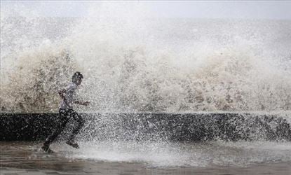
Furthermore the IMD has predicted heavy to very heavy rainfall at isolated places in kerala over the next few days, till June 13. Apparently in a joint statement with the Indian National Centre For Ocean Information Services (INCOIS), the IMD has also predicted high waves (around 3.5-4.4 meters) from 10.30 am on June 10 to 11.30 pm on June 11, along the coast of kerala from Pozhiyoor to Kasargod.
Accordingly for Karnataka, the IMD has predicted widespread rainfall with heavy rain in isolated places in coastal Karnataka, while south interior Karnataka will witness fairly widespread rainfall with heavy falls at isolated places till June 11 and then rainfall in a few places till June 13. Perhaps INCOIS has predicted high waves (3.5-4.5 meters) from 10.30 am on June 10 to 11.30 pm on June 11 along the coast of Karnataka from Mangalore to Karwar.
